

Land degradation remains a critical ecological challenge worldwide, undermining ecosystem services, food security, and sustainable development. The United Nations Convention to Combat Desertification (UNCCD) has established Land Degradation Neutrality (LDN) as a core Sustainable Development target, aiming to balance land losses with gains through sustainable land management and ecological restoration by 2030.
Conventional LDN assessments, however, rely on static comparisons with a fixed historical baseline. In arid regions with high climatic variability, this approach often conflates short-term climatic fluctuations with long-term degradation trends, making it difficult to pinpoint the persistently degrading areas that most urgently require intervention, creating a significant gap between global LDN reporting and a genuine understanding of local landscape processes.
To address this, a research team led by Prof. Alishir Kurban from the Xinjiang Institute of Ecology and Geography, Chinese Academy of Sciences (XIEG), has developed a novel Temporal Frequency Analysis (TFA) framework. The study was published in Catena on August 25, 2026. Dr. Anwar Eziz, a Special Research Assistant at XIEG, is the first author.
Rather than asking whether a pixel has degraded relative to an arbitrary past benchmark, TFA quantifies the recurrence of land degradation or improvement trends across consecutive assessment periods, using it as an indicator of landscape process persistence.
The methodcenters on the Land Productivity Dynamics (LPD) sub-indicator — the most responsive component of SDG indicator 15.3.1 in dryland systems — and draws on MODIS NDVI data spanning 2001–2022. The framework employed a five-year moving window and a full-period median dynamic baseline across ten overlapping assessment periods for pixel-level calculation of Degradation Recurrence (Rdeg), Stability Recurrence (Rstab), and Improvement Recurrence (Rimp).
Applied to the dryland provinces of Dashoguz and Lebap in Turkmenistan, TFA revealed a striking finding: both persistent degradation hotspots and persistent improvement bright spots are highly localized, each occupying less than 1% of the study area. This indicates that truly entrenched land degradation is geographically concentrated rather than widespread.
The analysis further uncovered contrasting degradation trajectories across land-use types. In Dashoguz, degradation hotspots clustered in areas of severe secondary salinization and around Sarykamysh Lake, closely linked to mineralized drainage discharge. In Lebap, hotspots were more scattered and associated with saline soils, abandoned irrigated cropland, and overgrazing. Persistent bright spots, by contrast, corresponded to successful land-management practices — including natural vegetation regeneration in Dashoguz and efficiently irrigated zones along the Amu Darya in Lebap.
The two provinces differed markedly in ecosystem resilience: districts in Lebap recorded stable-productivity recurrence rates of 74–76%, compared with only 23–46% in Dashoguz. The largest share of land — areas with 30–70% recurrence — was neither stable nor persistently degraded but dynamically unstable, representing both the greatest vulnerability and the greatest opportunity for intervention. At the protected-area level, the Gaplangyr desert reserve showed only 13.80% persistently stable area, indicating pronounced fragility, whereas the Amudarya riparian reserve maintained 63.30% stable area, reflecting a resilient, balanced ecosystem. Among irrigated croplands, stable conditions covered 49.64% in Lebap versus just 24.71% in Dashoguz, where the area of persistent improvement slightly exceeded that of degradation, suggesting a net positive trend.
By distinguishing recurrent degradation from transient climatic variability, the TFA framework transforms LDN from a retrospective reporting obligation into a dynamic, process-oriented diagnostic tool. It provides spatially explicit decision support for the LDN "Avoid–Reduce–Reverse" response hierarchy: reversal interventions can be targeted at compact degradation hotspots, preventive reduction measures deployed in dynamically unstable zones, long-term protection secured for stable areas, and successful practices from bright spots codified and scaled up.
Built on open-source tools (Trends.Earth, QGIS) and globally consistent datasets, the framework is readily reproducible without proprietary software or large-scale field campaigns. It offers a scalable methodological foundation for land-degradation assessment and adaptive management across the world's drylands and carries particular relevance for advancing sustainable land-resource use and LDN implementation in the arid regions of Central Asia along the Belt and Road.
Read the full article: https://doi.org/10.1016/j.catena.2026.110499
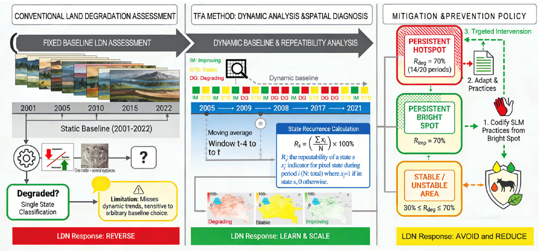
Conceptual framework of the Temporal Frequency Analysis (TFA) method. (Image by XIEG)
Contact
Anwar Eziz
Xinjiang Institute of Ecology and Geography
Email: anwareziz@ms.xjb.ac.cn
Web: http://english.egi.cas.cn